Storm Dave set to bring Easter gales, rain and blizzards to UK

- Published
The Met Office has issued updated yellow weather warnings for wind, rain and snow ahead of the arrival of Storm Dave.
A deep area of low pressure is expected to pass across the north-west of the UK on Saturday night with the threat of severe gales, flooding and blizzards.
Travel disruption, power cuts and damage are possible.
The forecast for the rest of the Easter weekend is very mixed, with snow for some and warm sunshine for others.
Multiple weather warnings
Northern and western areas of the UK will bear the brunt of the strong winds, with Met Office yellow warnings covering Scotland, Northern Ireland, northern England and parts of north and west Wales.
The warnings are valid at various times on Saturday afternoon, overnight and into Sunday.
Widespread gusts of 50-60mph (80-97km/h) are expected with the chance of 70-80mph (113-129km/h) in exposed areas, especially around coasts.
Central and northern Scotland may see winds peaking at 90mph (144km/h).

Latest warnings from the Met Office for Storm Dave
There is a risk of significant travel disruption during what is predicted to be the busiest Easter weekend in four years for drivers.
Bridges could close and ferry services may be cancelled, with possible delays to planes, trains and buses.
Rough seas and large waves will bring dangerous conditions around the coasts.
Parts of north-west Scotland are also covered by a Met Office yellow warning for rain and snow.
At low levels, especially in the Western Isles and Skye, up to 50mm (2in) of rain could fall with the potential for flooding.
Meanwhile hills and mountains above 200m (650ft) are likely to see snow, with 5-10cm (2-4in) expected to accumulate, and a small chance of 20cm (8in) in a few places.
Coupled with the strong winds this could give blizzards, snowdrifts and very poor visibility on the roads.
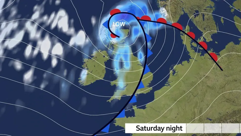
The centre of Storm Dave is expected to pass across the north of Scotland
Storm Dave is being propelled towards the UK by a powerful jet stream - the flow of winds high in the atmosphere that develops weather systems and guides them around the globe.
This has been supercharged by huge temperature contrasts across the US and Canada over recent days.
Storm names 2025-26: How do storms like Dave get their names?
- Published1 day ago
A mix of Easter weather
Storm Dave is just part of a weather story that will bring a variety of conditions across the UK during the rest of the long weekend.
Skies will clear on Good Friday night, albeit with a few showers.
Parts of Scotland, Northern Ireland and northern England may dip below freezing, meaning a frosty start to Saturday morning.
Cloud will then spill northwards across the country during Saturday bringing rain in northern and western areas, with snow developing over some Scottish mountains.
Central, southern and eastern parts of England may stay largely dry with some spells of sunshine.
Temperatures will range from 7C (45F) in northern Scotland to 17C (63F) in eastern England.
Winds will strengthen through the day ahead of Storm Dave's arrival.
Sun and snow on Easter Sunday
Easter Sunday will be a day of contrasts as the storm slowly loosens its grip.
Strong winds will continue to blow across Scotland, Northern Ireland and northern England, bringing a chilly feel and frequent showers.
Some of these will be wintry over hills and mountains, and perhaps even to low levels in northern Scotland for a time.
Further south the showers will be fewer and further between, with parts of Wales and southern England staying predominantly dry and bright.
UV levels are expected to peak at moderate in the sunniest spots.

Temperatures on Easter Sunday will range from 7C (45F) in northern Scotland to 13C (55F) in south-east England
As winds ease on Sunday night things will turn cold with a widespread frost.
However after a chilly start to Monday temperatures will climb through the day, with southerly winds bringing afternoon highs of 10-16C (50-61F).
Most areas will be dry with patchy cloud and sunny spells, which is expected to bring high or very high pollen levels.
Check the Met Office pollen forecast for your area below. Levels range from L for Low to VH for Very High.
Tuesday currently looks set to turn even warmer with 20C (68F) looking possible in parts of England and Wales.
Beyond that there is uncertainty in the forecast, but many computer weather models suggest it will turn cooler and more unsettled, with a return to April showers and the risk of further strong winds.
You can always keep up-to-date with the longer range prospects with our monthly outlook - and follow the hour-by-hour forecast for your area by checking the BBC Weather app.
More weather stories
- Published1 day ago

- Published18 hours ago

- Published1 day ago